

El Niño: Current Situation and Outlook for Argentina
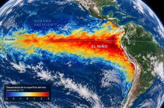
The strengthening of El Niño during 2026 coincides with a period of heavy rainfall, rising rivers and flooding across parts of South America. In Argentina, the main alerts currently focus on the Litoral region, where the Paraná and Uruguay river basins receive rainfall runoff from both Argentine territory and neighboring countries.
Author: Telma Zerdá, graduate in Geological Sciences, specialist in environmental monitoring of soil, water and air.
The strengthening of El Niño during 2026 coincides with a period of heavy rainfall, rising rivers and flooding across parts of South America. In Argentina, the main alerts currently focus on the Litoral region, where the Paraná and Uruguay river basins receive rainfall runoff from both Argentine territory and neighboring countries.
But the situation extends beyond flooding. In Chile, a succession of recent events included mudslides, intense thunderstorms and a low-intensity tornado in Santiago. At the same time, climate outlooks for the coming months suggest that conditions favorable to rainfall will persist in some Argentine regions, although with significant differences between the country's east, center and west.
The central question is whether El Niño has already reached its peak intensity and how long its effects might persist. Answering it requires distinguishing the state of the Pacific Ocean, the weather impacts observed and the hydrological evolution of river basins.
THE STATE OF EL NIÑO: HAS IT ALREADY REACHED PEAK INTENSITY?
As of October 16, 2026, available information indicates that El Niño is strengthening and that the episode could reach exceptional intensity.
The Japan Meteorological Agency reported on October 9 that the sea surface temperature anomaly in its monitoring region had reached +4.0 °C in September, the highest value recorded by the agency since observations began in 1949. The agency also indicated a 100% probability that warm conditions would persist throughout the Northern Hemisphere winter.
This figure is significant but needs clarification: temperature anomalies can vary depending on the Pacific region being assessed and the index used. Therefore, the value
reported by Japan should not automatically be interpreted as a universal classification of intensity.
Projections released in recent days indicate that the phenomenon could continue to strengthen and peak around December 2026 or early 2027. However, the exact timing of the peak remains uncertain.
Available information points to an episode that continues to intensify, with a possible peak over the coming months.
It is also important to distinguish the peak in ocean warming from the period of greatest impacts in Argentina. The largest river floods may occur weeks or months after the rainfall that caused them because water needs time to travel through river basins.
ARGENTINA: HEAVY RAINS, RISING RIVERS AND FLOODS
The most visible impact of recent weeks has been concentrated in northeastern Argentina and Mesopotamia, where heavy rain and rising levels in major rivers have led to evacuations, restrictions and disruption in riverside communities.
However, not all events have the same cause. In some communities, flooding from local rainfall predominates; in others, rising river levels result from water flowing in from upstream basins, including outside Argentina.
2.1. Concordia and the Uruguay River basin
Concordia, in Entre Ríos province, is among the areas facing a worrying hydrological situation.
Rainfall in the Uruguay River basin raised river levels and required assistance operations and preventive evacuations. The situation in Concordia must be examined in relation to cumulative rainfall across the basin and inflows arriving from Brazil.
The city lies downstream from the Salto Grande reservoir. Dam operations can affect river flows but cannot eliminate flood risk when inflows are high and persistent.
To interpret the event correctly, it is necessary to distinguish:
the river level measured in Concordia;
the flows entering the Salto Grande reservoir;
rainfall in the upper and middle basin;
forecasts of flow and river levels for the following days.
According to information released on October 11, rising levels in the Uruguay River forced families to evacuate in Concordia and other communities in Entre Ríos and Corrientes.
2.2. Paso de los Libres and the Corrientes stretch of the Uruguay River
In Paso de los Libres, Corrientes province, the Uruguay River exceeded the evacuation threshold in recent days, prompting the preventive transfer of residents to assistance centers.
The episode shows that hydrological risk is not confined to Concordia: communities across the basin can experience flooding at different times depending on their location, the scale of inflows and the shape of the river channel.
In this region, monitoring river levels and rain forecasts in Brazil and Argentina is essential for anticipating how the emergency will evolve.
2.3. Iguazú: extraordinary flooding and temporary closure of the Falls
On October 13, increased flow in the Iguazú River prompted the temporary closure of tourist access to the Falls. Flow exceeded 12,000 m³/s, approximately six times the quoted river average.
The situation was linked to heavy rainfall in the basin and increased upstream inflows. Tourist access reopened the following day after the flow began to recede.
This event is particularly important for analysis because it shows how a global-scale climate phenomenon can affect a river system shared by Argentina and Brazil.
TRANSBOUNDARY BASINS: HOW EVENTS IN BRAZIL, PARAGUAY AND BOLIVIA HAVE AN IMPACT
Argentina receives water from major river systems that originate in or cross other countries. As a result, flooding can be linked to rainfall hundreds or thousands of kilometers away.
El Niño does not affect these systems uniformly. It can favor wetter conditions in parts of South America, but hydrological outcomes depend on the distribution of rainfall, duration of events, soil moisture, tributaries and reservoir operations.
3.1. Brazil and the Iguazú River basin
Rainfall in southern Brazil can cause rapid increases in the Iguazú River's flow, which then move toward Argentine territory.
During prolonged rainfall, the response can be very rapid. Floods affect the Falls, access roads and riverside areas, even though conditions are not necessarily the same throughout the basin.
The October flood is a recent example of the importance of joint monitoring by the two countries.
3.2. Brazil and Paraguay: the Paraná system
The Paraná River receives water from a vast basin spanning parts of Brazil, Paraguay and Argentina.
Rainfall in the upper and middle basins can increase flows entering Argentine territory. When these inflows coincide with local rainfall, flood risk may rise.
In the Paraná's case, a simplistic interpretation must be avoided: high river levels in Argentina do not necessarily mean heavy rain fell in the affected community. Flooding may be linked to rainfall elsewhere in the basin.
3.3. Bolivia and northern Argentina's basins
In northern Argentina, the Bermejo and Pilcomayo basins receive water from rainfall in Bolivia.
Rain in the upper basins can increase flows, carry large quantities of sediment and cause flooding in parts of Salta, Jujuy, Formosa and Chaco.
However, flooding in the Bermejo or Pilcomayo should not automatically be attributed to El Niño. Establishing that link requires checking rainfall in the upper basin, river levels and changing flows.
In this region, intense rainfall events can trigger major hydrological responses even when local rainfall is scarce.
CHILE: MUDSLIDES, THUNDERSTORMS AND A TORNADO IN SANTIAGO
Recent events in Chile show that the regional climate situation is not limited to river flooding.
On October 8, a mudslide affected Las Condes in Santiago. It was described as a sudden flow of water and sediment descending from the Andean foothills toward urban areas.
Among the factors identified were heavy rainfall, the high altitude of the freezing level and terrain conditions that favored runoff and sediment transport.
On October 13, another intense thunderstorm hit Santiago, bringing torrential rain, hail, flooding and material damage. Chile's Meteorological Directorate classified the event in Estación Central as an EF0 tornado, although there was initial debate over whether the damage might have resulted from another type of wind event.
These episodes should be approached with caution: attributing every mudslide or tornado directly to El Niño is incorrect. The phenomenon can change regional circulation and moisture conditions, but extreme events also depend on local factors and the specific atmospheric dynamics of each storm.
THE TORNADO CORRIDOR: ARGENTINA AND PARAGUAY
Argentina and Paraguay belong to a South American region characterized by severe storms, some of which can produce tornadoes.
The area is often called the tornado corridor, although it is neither a fixed strip nor a place where tornadoes occur continuously. It is a region where atmospheric conditions can coincide and, under certain circumstances, favor powerful storms.
Factors that can contribute to severe storm formation include:
moisture available from tropical regions;
warm, humid air at low levels;
the arrival of colder or drier air at higher levels;
atmospheric instability;
changes in wind direction or speed with altitude, known as wind shear.
El Niño can influence atmospheric circulation and alter some of these conditions, but it cannot by itself predict tornadoes in a specific community.
Over the coming months, monitoring should focus on the likelihood of severe storms, not assertions that tornadoes will occur in a particular region. Seasonal forecasts can indicate rainfall-favorable conditions but cannot precisely predict the location, day or intensity of a tornado.
WHAT CAN ARGENTINA EXPECT IN THE COMING MONTHS?
Climate outlooks indicate that the risk of abundant rainfall may persist in east-central Argentina during the Southern Hemisphere spring and summer.
The National Meteorological Service has indicated an increased probability of above-normal rainfall in parts of the Litoral and central region during the October–December quarter.
Nevertheless, seasonal forecasts must be understood as probabilistic trends. They cannot precisely determine how much rain a city will receive, when flooding will occur or which river will reach a given level.
Litoral and Mesopotamia
The main risk is continued heavy rain and flooding in the Paraná, Uruguay and Iguazú basins.
Monitoring flows in Brazil, Paraguay and Argentina will be essential to anticipate river levels in riverside communities.
Pampas and central region
The prospect of above-normal rainfall could increase waterlogging risk where soils are saturated, drainage is inadequate or rainfall persists.
Risk assessments should account for the combination of local precipitation and inflows from nearby basins.
Northwestern and western Argentina
Rainfall patterns may be more variable. It should not be assumed that all northern Argentina will receive heavy rainfall simply because El Niño is under way.
Regional trends must be checked against the National Meteorological Service's seasonal forecasts and rainfall records from each province.
Patagonia
The region responds less uniformly to ENSO. Rainfall, snowfall and temperature outlooks depend on atmospheric circulation and the specific conditions in each area.
In western Patagonia, trends in precipitation and accumulated snow are important for water availability over the coming months.
EL NIÑO AND CLIMATE CHANGE: TWO PROCESSES THAT CAN INTERACT
El Niño is a natural climate variability phenomenon. Climate change, by contrast, involves a long-term transformation of the climate system, primarily associated with increasing greenhouse gases.
The two processes can interact.
A warmer atmosphere can hold more water vapor, potentially intensifying rainfall when conditions favor storm formation.
However, this does not mean climate change automatically turns every El Niño episode into an extreme event, or that every flood is a direct consequence of global warming.
Attributing a specific event requires analyzing observations, climate models and attribution studies.
CONCLUSIONS: A SCENARIO CALLING FOR HYDROLOGICAL AND METEOROLOGICAL MONITORING
In mid-October 2026, El Niño continues to develop and projections suggest a possible peak late this year or in early 2027.
In Argentina, river rises and flooding in the Litoral are among the most important signs of impact in recent weeks. Concordia, Paso de los Libres and the Iguazú River system show how rain in shared basins can affect Argentine communities even when inflows originate abroad.
Recent events in Chile, meanwhile, are a reminder that atmospheric impacts are not confined to river flooding: they can also include mudslides, severe storms, hail and damaging wind events.
The outlook for the coming months requires continuous monitoring of climate forecasts and river levels. El Niño can increase the likelihood of certain rainfall patterns, but the severity of each emergency will depend on weather developments, basin conditions and population exposure.
The most useful information for prevention will be that which integrates climate forecasts with short-term weather advisories and basin-specific hydrological warnings.